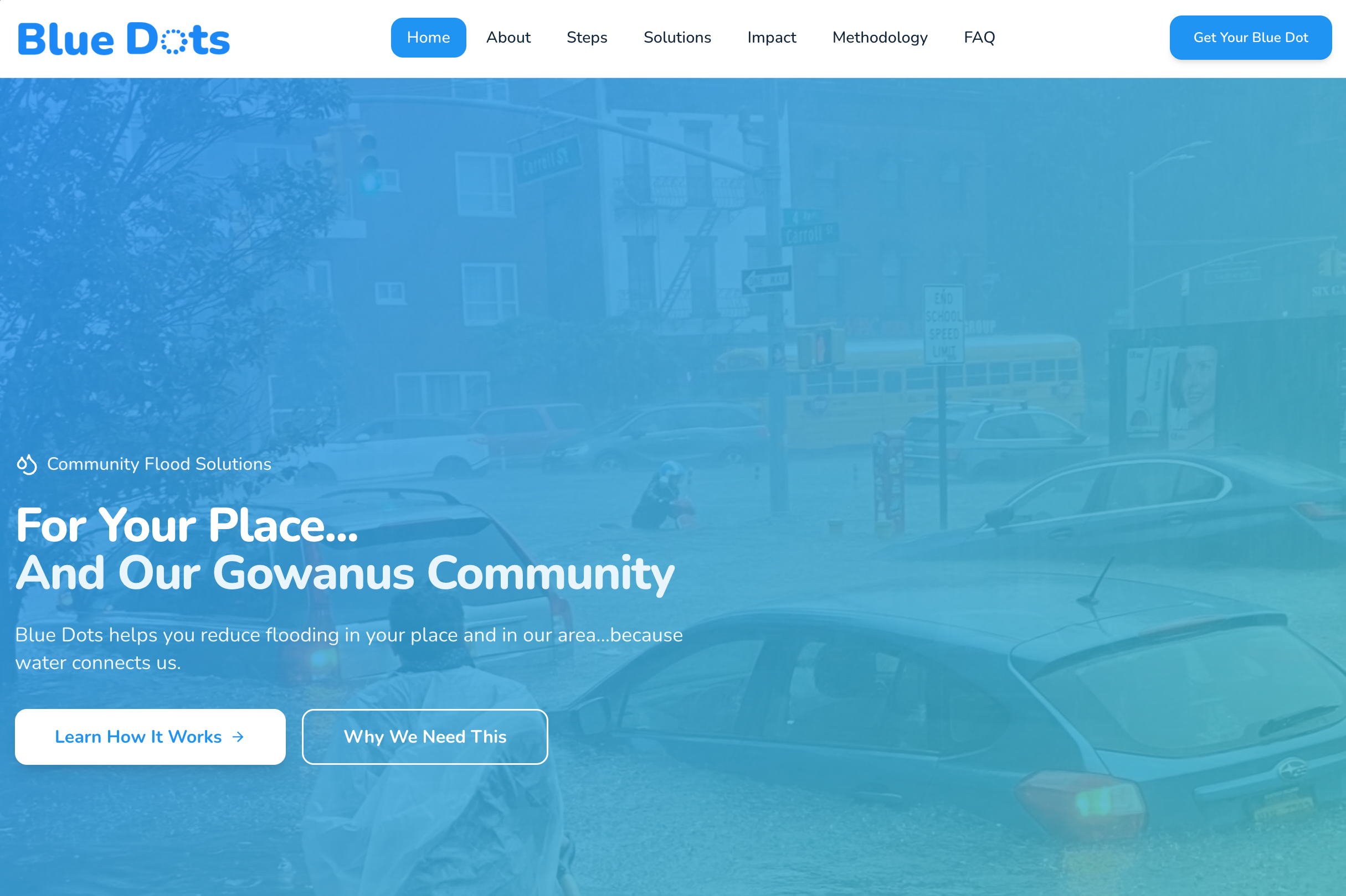
Blue Dots
Empowering community members to implement solutions that prevent flooding in your place in your neighbor's place, and help clean our shared waterways.
The Issue
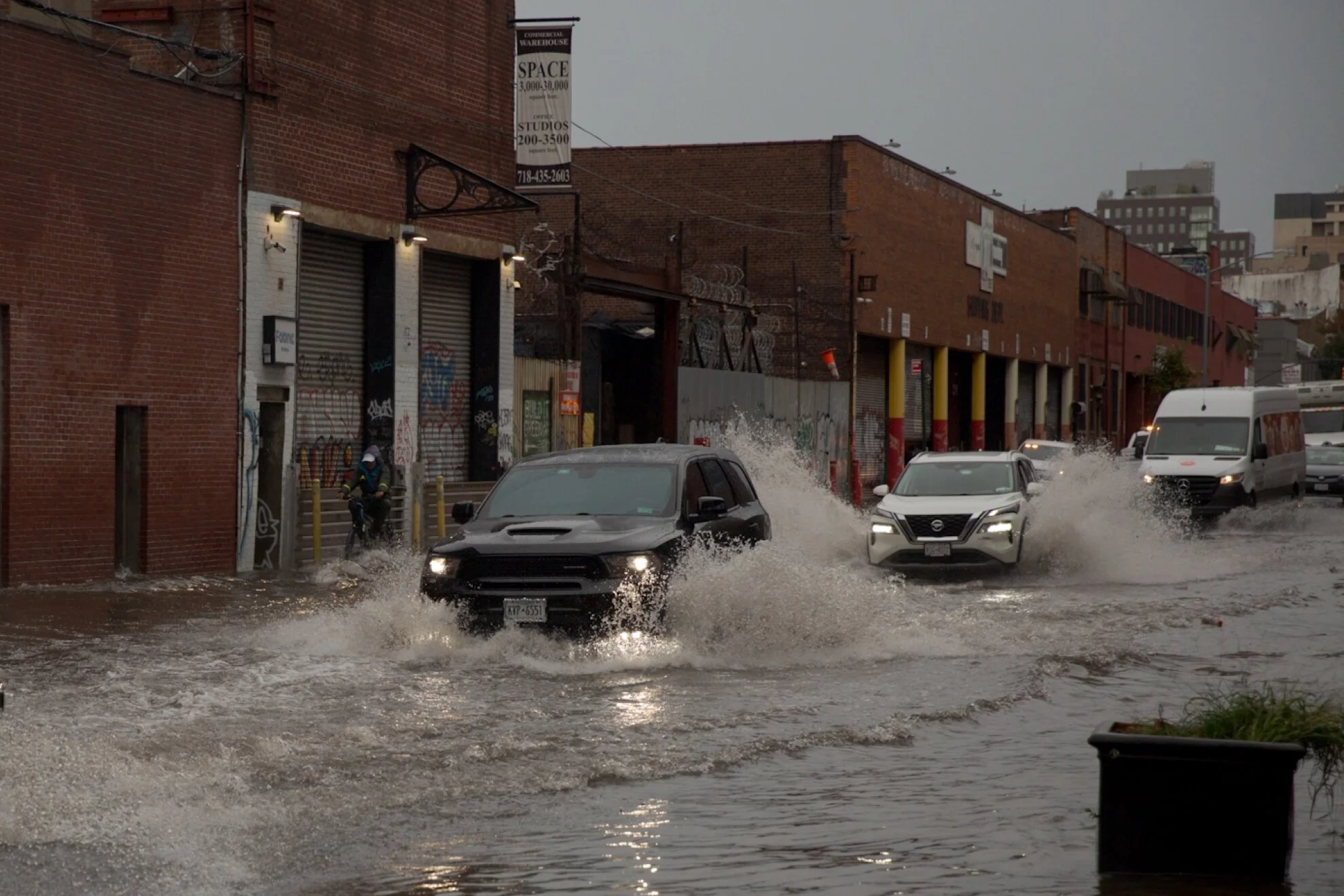
Stormwater flooding is overwhelming NYC’s streets, homes, and sewer system.
As rainfall intensifies, even small amounts of water can compound block by block — flooding basements, backing up sewers, and discharging untreated wastewater into local waterways. Yet most property owners don’t know their specific flood exposure, or which mitigation actions would meaningfully reduce it.
When flooding occurs, solutions are often reactive and disconnected. Individual upgrades — if they happen at all — remain invisible, uncoordinated, and difficult to measure at the neighborhood scale. Without a shared framework, distributed actions fail to add up, and communities miss opportunities to reduce peak stormwater pressure before the next storm.
Blue Dots turns property-level action into coordinated neighborhood resilience.
What is Blue Dots?
Blue Dots is a property-based flood prevention platform. It helps homeowners, renters, and neighborhood partners identify practical mitigation actions — and turn individual flood exposure into visible, block-by-block resilience.
Blue Dots focuses on preventing flooding before it happens by helping properties retain, redirect, and reduce stormwater at the source.
List of Solutions Preview
Address-Based Flood Snapshot: Understand relative flood exposure using aggregated stormwater, coastal, sewer backup, and historic flow data.
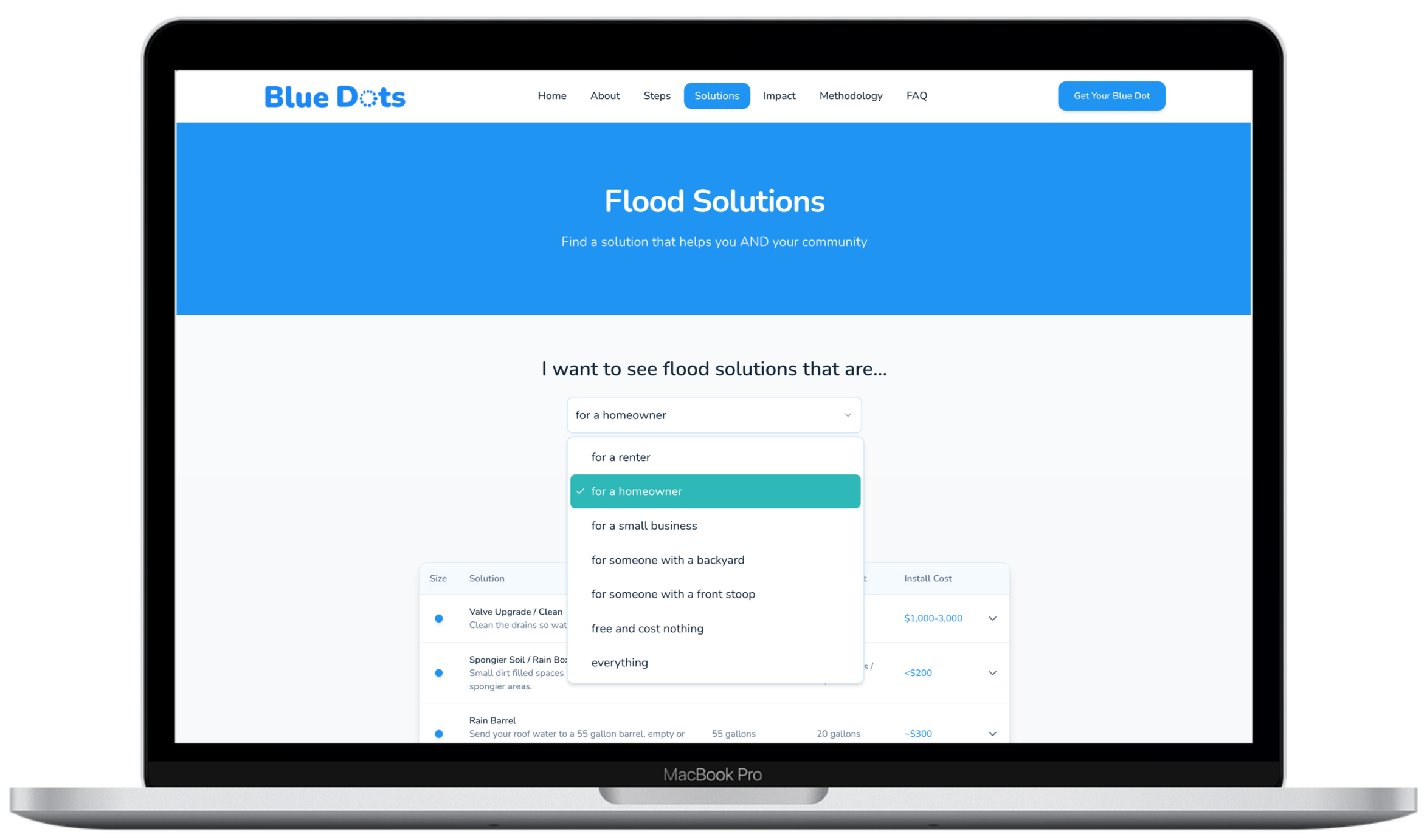
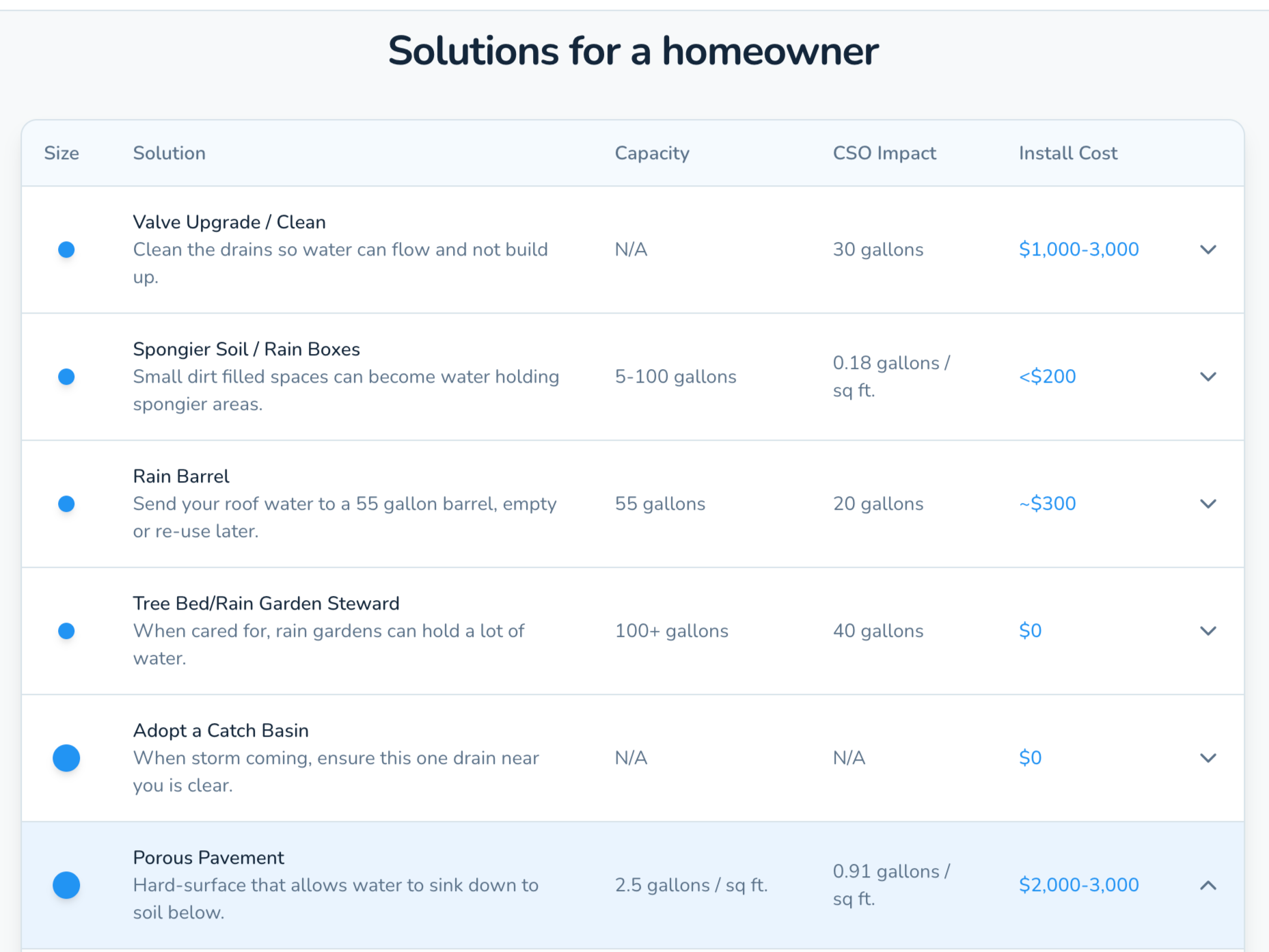
Personalized Mitigation Menu: Plain-language solutions tailored to building type, budget range, and site conditions.
Compare What Works: Evaluate options by cost, stormwater capacity, and neighborhood-scale impact.
Pathways to Local Help: Connect to trusted contractors, community partners, and financing resources where available.
Earn a Blue Dot: Completed actions are mapped (with privacy protections), contributing to visible neighborhood progress.
For Homeowners & Renters
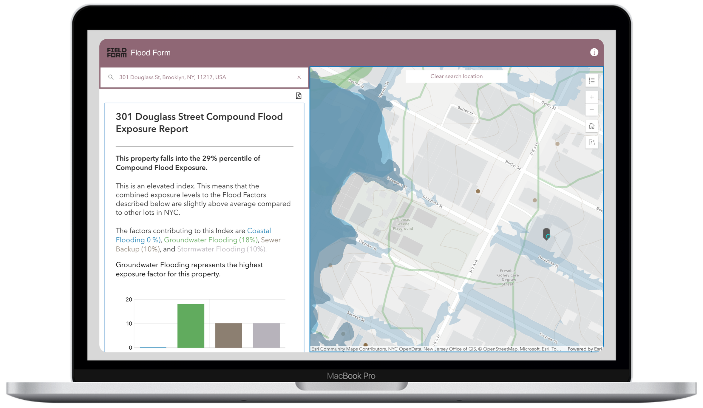
Address Based Flood Snapshot
For Community Partners
(CBO’s, Elected Officials, Lenders, BIDs)
Blue Dots transforms distributed property-level action into actionable neighborhood intelligence.
Map of Installed Mitigation: See where resilience investments are happening — and where gaps remain.
Standardized Solution Framework: A shared menu of stormwater-retaining interventions that supports consistent outreach and funding alignment.
Engagement & Conversion Metrics: Track participation from risk assessment to completed installation.
Archived Documentation: Aggregated evidence to support grant applications, infrastructure advocacy, and watershed planning.
Community-Level Water Impact: Quantify cumulative stormwater retention and CSO reduction potential.
How Blue Dots Works
01 — Find Your Solution
Blue Dots begins with an address-based flood snapshot that aggregates public data on stormwater, coastal flooding, and sewer backup to estimate relative exposure. From there, users receive a structured, plain-language menu of mitigation options tailored to building type, budget, and site conditions — helping residents move from awareness to practical, property-based action.
02 — Submit Your Blue Dot
Once a mitigation solution is installed, users document their action through a simple submission process. Verified interventions earn a “Blue Dot” on the neighborhood map (with privacy protections as needed), turning individual property upgrades into visible, standardized community resilience data.
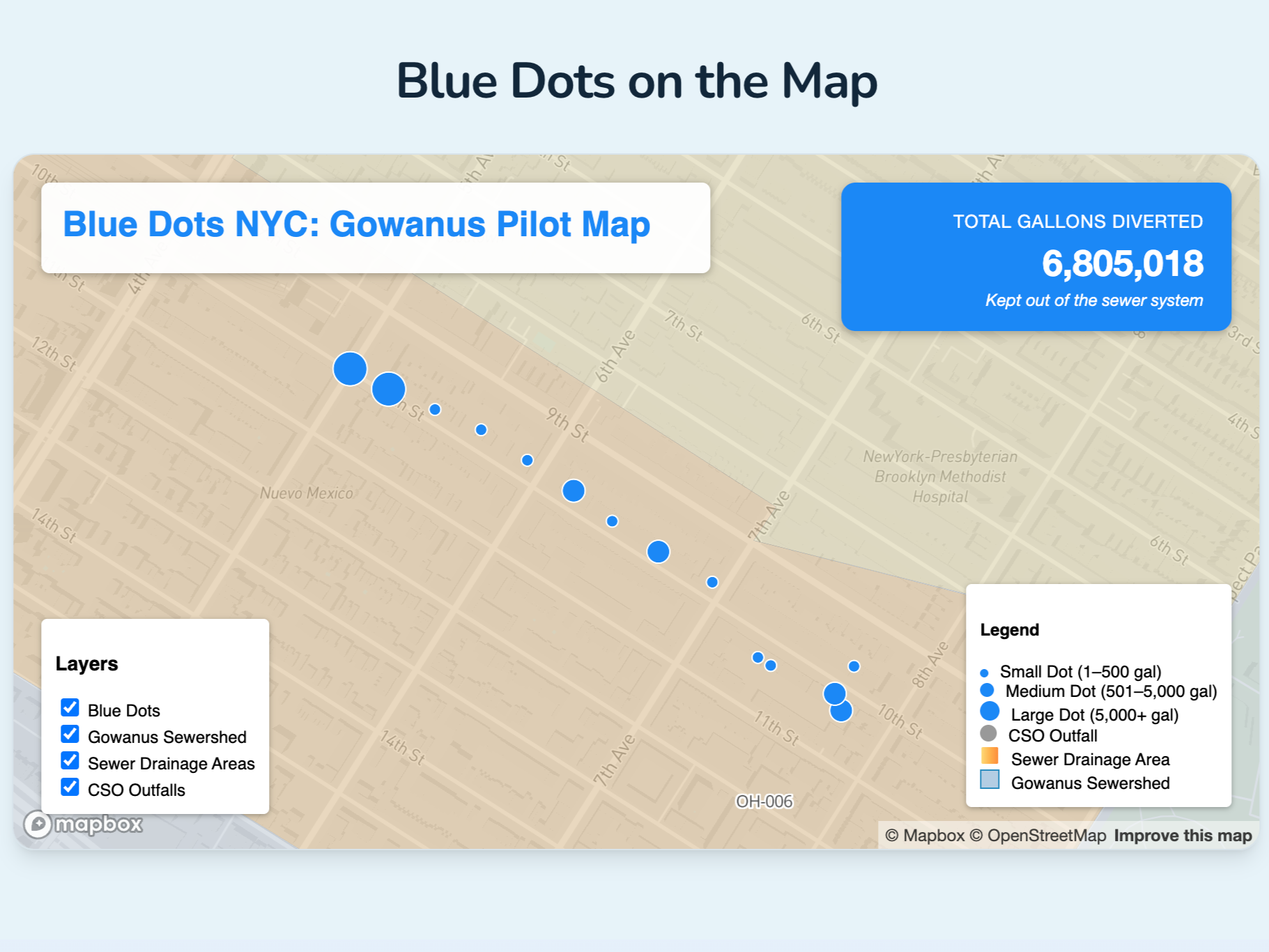
03 — See Your Impact
Every Blue Dot contributes to a live resilience map that shows where mitigation is happening — and where gaps remain. Over time, cumulative participation demonstrates block-by-block progress, supporting funding, advocacy, and watershed-scale flood reduction.
Visit Blue Dots
Blue Dots helps you understand your flood exposure, compare property-based solutions, and contribute to visible neighborhood resilience.
Start with your address, find what works for your place, and see how your action becomes part of a community-wide effort.
Frequently Asked Questions
-
Blue Dots is a community-driven initiative focused on preventing flooding in Brooklyn neighborhoods. We help property owners implement simple water management solutions that, when combined across many properties, create significant flood protection for entire communities.
-
We are starting with a focus on flood-prone neighborhoods in Brooklyn adjacent to Gowanus: Park Slope, Greenwood, Carroll Gardens, Cobble Hill and Boerum Hill. Once we get this pilot off the ground and learn how we can improve it, we are open to expanding to additional communities based on need and community interest.
-
When it rains, runoff from nearby sloped areas flows into NYC's combined sewer system, which carries both sewage and stormwater. Heavy storms overwhelm the pipes, causing Combined Sewer Overflows (CSOs) that dump untreated sewage into the Gowanus Canal. Because the canal has limited water circulation, this pollution lingers instead of flushing away. There are a total of 11 combined sewer overflow (CSO) sites that can discharge to the Canal and we want to lower the amount of water that hits them at peak times.
Learn more at NYC Department of Environmental Planning Plans
-
We use performance data from the NYC DEP Green Infrastructure reports to estimate stormwater capture and avoided combined sewer overflow. Each property's impact is calculated based on the specific solutions implemented and aggregated to show community-wide benefits.
-
We needed a denominator that estimates how often the problem occurs in this sewershed. The most recent statistic available was from June 30th, 2015 (the Gowanus Canal Long-Term Control Plan) which cites that for CSO Outfall OH-006, in Gowanus Canal, there were 32 events. This is actually a conservative estimate given its date and that increased heavy rains have increased since 2015. The impact could be larger and more frequent. But we are erring on the side of caution and will update if we find better CSO event data.
Sources:
-
When you register your property and implement water management solutions, you become a 'blue dot' on our map. Each blue dot slows and absorbs rainwater during storms. When thousands of properties do this together, we create a distributed network that significantly reduces flood risk and combined sewer overflows.
-
No you don't need to own. Renters and small businesses can do things too, and probably need to. While property owners have the most flexibility, renters can also participate with landlord permission for certain solutions. We can help you understand what options are available for your situation. -
Blue Dots is free: so using the site, finding your solution and registering for a Blue Dot cost nothing. Implementing a solution can have varying degrees of cost, depending on what you need and if there are any rebates, incentives you qualify for (which we also hope to connect you to). When appropriate, we provide a link to a separate flood-related web site (The City Sponge) where you can see local trades who specialize in these solutions, products/services related to flooding, gov't grants as well as local community partners who offer resilience-focussed financing. We want to help you at all steps so it gets done.
-
Yes, we would really like to know about it, give you the credit you deserve and also add it into the impact calculations. Simply fill out the "Get Your Blue Dot" form and indicate what you did and we will review.
-
Solutions range from simple to more involved: rain barrels, downspout diversions, rain gardens, tree bed improvements, porous pavement, green roofs, and more. We'll help you identify which solutions work best for your property based on its size, layout, and your budget.